
skymarathon 42km
7:20 am Sunday March 21, 2027
Meet: Event Village for 5:20am SHarp Shuttle departure
START: Mount Buffalo Chalet
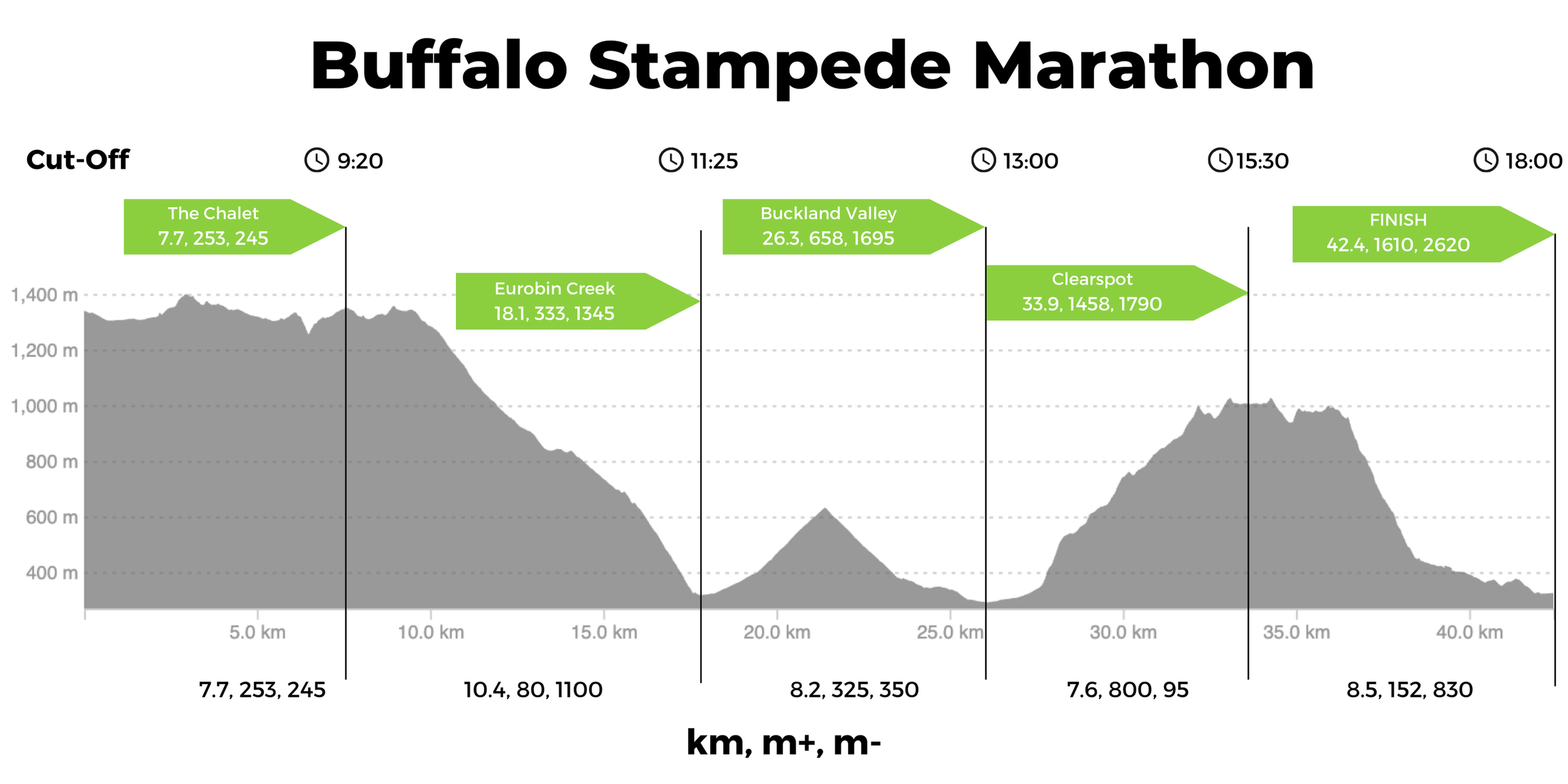
Stats: 42 km, 1600m Ascent+, 2650m Descent-
Wave Starts: wave 1 (7:20am); Wave 2 (7:25am); Wave 3 (7:30am)
Total Cut off: 10:30 hours (6PM)
Prizes:
1st🥇$1,000 > 2nd🥈$600 > 3rd🥉$400
Course overview
Starting at the Mount Buffalo Chalet, athletes will cover a loop up the top of the Mount Buffalo Plateau. Starting on a beautiful wide road, runners will have the chance to spread out and find their place in the field before turning onto dreamy single trail. Run through The Monolith trail and the Underground River Track before returning to the Chalet for a quick pit stop.
Descend down the epic Big Walk, 10k trail descending 1000m, to Eurobin Picnic Ground. Watch out for the technical trail at Mackey's Lookout and try not to trip when marvelling at the views.

Grind over Keatings Ridge, Up and Down 6km with 310m+-. This dirt road brings you through a serene forest of the beautiful Mount Buffalo National Park.
Traverse the 3km of road in the Buckland Valley. Be sure to enjoy the faster running and see your crew along Harris Lane.
Now comes the crux of the race, the Dingo Ridge climb to Clearspot! From the Right Turn onto Dingo Ridge Road to the Clearspot Aid Station you'll climb 757m+ over 6.29km. The climb is a beast, and situated at this stage of the race it can really hurt. Also, it can get very hot, so make sure you carry extra water from the Buckland Aid Station (we now have a water point on Dingo Ridge to assist in cooling runners).
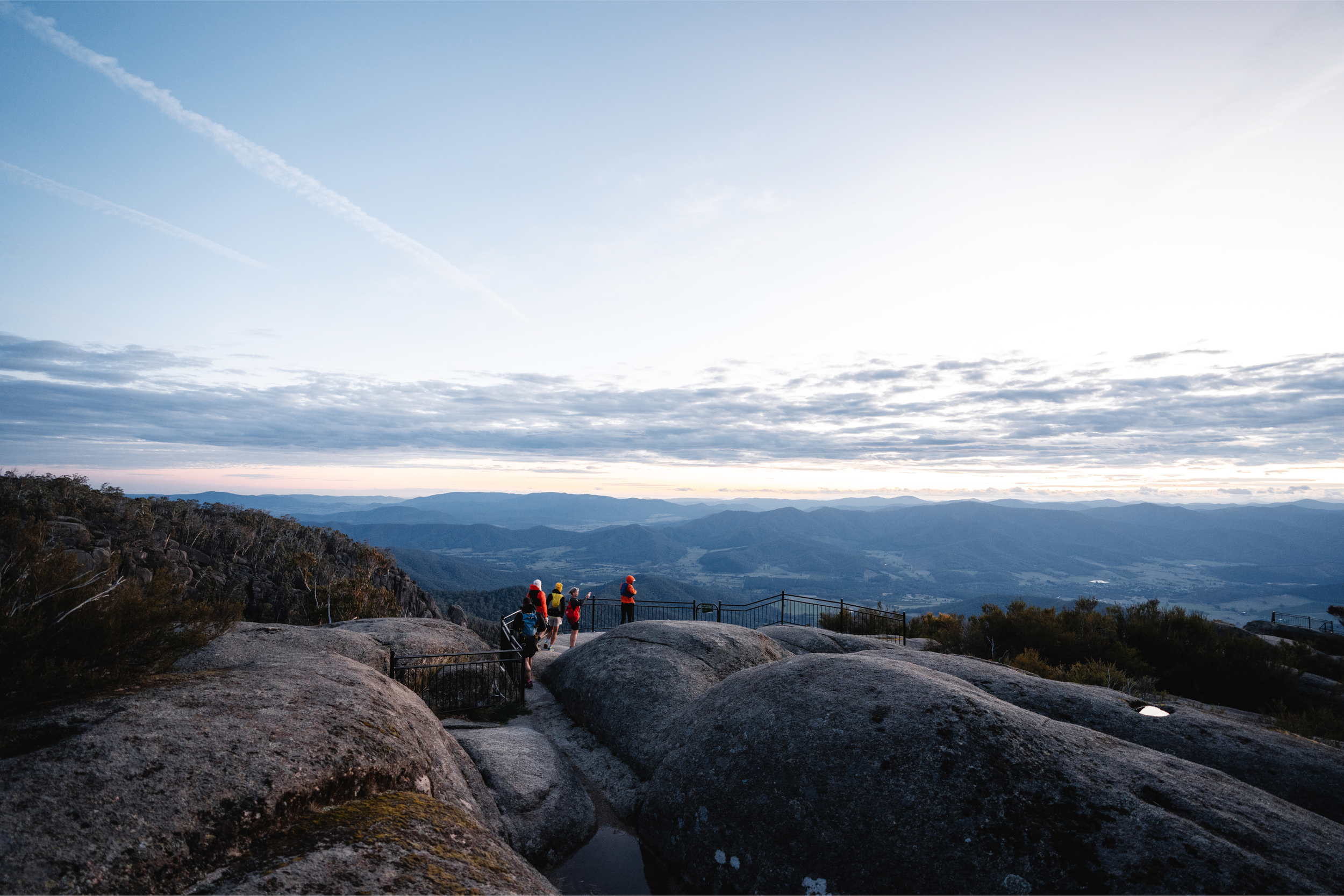
Recoup to the spectacular views of Clearspot Aid Station, then turn around for a little out and back to the high point of Eagle Peak before heading back along Water Reserve Track to the Top of Middle Track. Last year Middle Track was included as an early climb in the 100k, this year is the final descent. It is loose, rocky and technical. Every runner will be in full survival mode.
From the bottom there is less than 5km to go mostly downhill! Scoot down some sweet local singletracks in Bakers Gully until you hit the backstreets of Bright. Eventually the view of the Pavillion and the Event Village opens up. Soak in the final lap of honour, you deserve all the applause.
maps
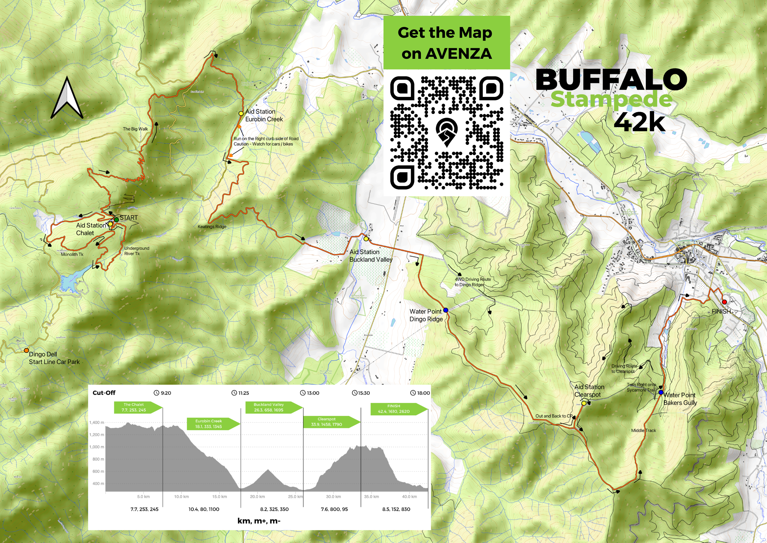
AVENZA mAP
It is important that everyone download the AVENZA Map before the Event. Along with having the GPX file in your watch, this is the best thing to allow you to get back on course if you are unsure where you are. Course tampering does happen, or people miss a turn easily in trail running. So you need to have a map to know where you are.
Download the AVENZA Map App to your phone. In the Store search for the Keywords “Buffalo Stampede 42k”, or scan the QR code below on your phone, or click the link on your phone. Then click “Free” next to the map to download the map for offline use on your phone. If you open the map, as long as you have enabled AVENZA to use your location, you will be able to locate where you are on the map and which way you are facing by clicking the little arrow. You can open and use this map even with no reception.
When you have the map open, have a play around. It is very useful. You can see the coordinates of the pointer down the bottom of the screen as you pan around the map. You can also press the draw icon in the bottom left to measure the distance between points.
-
The Buffalo Stampede Marathon has become an icon on the trail running scene. It has a fabled history with many great runners coming to compete. But even more compelling is that it is a point to point course from Mountain to Town with a Net Downhill of 1000m of elevation. Furthermore it is broken up into clear sections being the Mount Buffalo Plateau, the Big Walk downhill, Keatings ridge, Buckland Valley, onto Dingo Ridge and through the pine plantations and steep tracks to arrive in Bright.
Start with 2 km of road, leaving the Mount Buffalo Chalet and heading back along the road. This is a smooth start to the race and allows runners the chance to find their place in the pack before hitting the single trail.
Once at the Monolith Track, runners turn Left onto the trail after the road section. There may be a little congestion here with 900 runners, but that is why there are three wave starts and it should be a fairly smooth transition. The Monolith track is an undulating climb and descent on pristine Mount Buffalo trail.
Runners then emerge from the end of this trail onto the dirt track which runs towards Lake Catani. This is 1.5km of wide trail which, being mostly downhill, could find yourself getting a little too excited with your paces. Try to ease up and appreciate where you are, the bush and the rocks you are running through are ancient and a truly special place to be.
Once at the Underground River Track, runners turn left onto the trail and begin this technical route back to the Chalet. The route sidles along for a while before descending steep down to the underground river. From there it is a stepped climb to a couple well known lookouts and then not far to the Chalet for the first Aid Station.
After a quick pit stop at the 7.5km aid station you begin the long descent down the Big Walk to Eurobin Creek. This is the crucial section of the course that makes it what it is, a downhill classic. You’ll drop over 1000m- from the high granite cliffs to the valley floor. Along the way the trail changes from switchbacks and large rocks in the alpine trees, to very technical and exposed to the sun with views, to more runnable ribbons of dirt to a steeper and tighter drop at the end. You’ll feel the change in flora and atmospheric conditions as you drop. It will warm up, the foliage thickens and so does the air.
At Eurobin Aid Station it is a good idea to do a health check and allow the legs to absorb the enormous descent before heading off on the gradual climb of Keatings Ridge. Leaving the aid station there is 1km or running on the road, so please be careful and give cars plenty of space to drive around safely. Stick to the RIGHT hand side of the road as you run up to the base of Keatings Track.
Once on the track the course ascends a nice graded climb along a picturesque dirt road through the National Park. Do not forget about this climb as it is still a hefty 320m of ascent and descent on the other side. Once at the top you can test your downhill legs once more and hope they are in a good condition to tick off some easy km’s to the Buckland Valley.
At the bottom you’ll leave the National Park and head onto the 3km Road section through the Buckland, half way along which you’ll find the super critical Aid Station of Buckland Valley. Stop here and recuperate. From here you still have all the hard climbing of the race and it gets Hot along Dingo Ridge. So make sure you are fully hydrated, electrolyte-d, and carb-d up before leaving. On a hot day, take at least TWO (2) Litres of liquid from here.
Once off the road and onto Dingo Ridge you are presented with a Wall! The climb starts steep and gives you a taste of what is to come. Scramble your way up the first pitch any way you can. Here it may be useful to have poles. The climb does flatten out periodically, but then there are steep sections all the way along, with many false summits. In total you’ll run 7.5km with 800m to Clearspot, with the actual climb being around 6km. It gets hot along Dingo Ridge, and so we have added a water point to the climb about a third of the way up. Here you’ll be able to refill 500ml. Please do so, you’ll need it.
Near the top you’ll summit Lyrebird Peak first, before descending to Clearspot Rd and then Climbing again to Eagle Peak, which is a tough pitch, before finally descending to the Clearspot Aid Station. Take a breather and soak in the enormous views and marvel at Mount Buffalo to the West, where the journey began.
Leaving the aid station you’ll run around the rock pylon and do a U-turn to head back along the course to Eagle Peak. Hand out some hi fives to runners descending to the aid station. Then at the Peak you’ll turn Left and continue along your way on Demon Ridge. This undulating ridge line turns into Water Reserve Track before hitting the top of Middle Track. Here is the final test, the 500m descent of the rocky, loose and technical Middle Track. This will challenge all runners on tired legs and truly put your pacing strategies on the downhills to the test.
At the bottom of this steep downhill is a basic Aid Station at Bakers Gully. You only have 3.6km to go from here on mostly runnable terrain, but it may be necessary to restore your legs a little and have something to eat and drink. These final kilometres are good running on either smooth dirt trails or paved footpaths, it is also mostly a gradual downhill.
It starts in the buttery single tracks of Bakers Gully, then you’ll scoot around the back of some houses and onto Ballroom Court. From here it’s only 500m to go on paved roads before you head into Pioneer Park. You can see the finish line across the oval. Head around the road and soak it all in, your one way journey from mountain to town has been accomplished.
-
We are not allowing people to drive up to the start line at the Chalet and park or be dropped off. Every runner in the 42k and Grand Slams must catch the shuttle to the Start line from the Event Village at Pioneer Park in Bright. Shuttles are included in the price of yout entry fee, so just show up just after 5am at Pioneer Park on Sunday. Shuttles DEPART at 5:20am SHARP Sunday.
We have had many requests from some people who get car sick that they drive themselves, so we have a solution. Runners and Crew will be able to Drive and Park at Dingo Dell.
Dingo Dell will also be the Drop Off point for runners who are just getting dropped off by their crew. Runners will not be allowed to get dropped off at the Chalet. The road is closed!
Dingo Dell has a large carpark on the Mount Buffalo Tourist Rd. Crew can park here with their runners and catch a rolling shuttle to the start line. SingleTrack will provide a regular shuttle service between Dingo Dell and the Start Line at the Chalet (8 min drive) between 6:15 am and 7:00 am.
Then Crew will be able to return to their cars via a rolling shuttle between The Chalet and Dingo Dell between 7:30 AM and 9:00 AM.
This option of driving and parking at Dingo Dell is open to everyone, however we highly encourage people to catch the shuttle bus.
-
There will be 3 Waves Starts for the Marathon. This is to reduce trail congestion due to the large field sizes. We believe this will improve runner’s experience of the race and allow you to enjoy the beautiful trails on top of Mount Buffalo.
START TIMES:
WAVE 1 (Front runners) - 7:20AM
WAVE 2 (Mid pack) - 7:25AM
WAVE 3 (Slower) - 7:30AM
Runners Times will be based off chip timing. Runners will be allowed to start in whichever Wave they choose. Be aware that usually we have 60% of runners choosing to be in Wave 2, so if you want to avoid congestion, you may do better to start in Wave 3.

The 42km Sky Marathon is a UTMB® World Series Qualifier Event.
All runners who complete the course gain qualifier points for their UTMB® Index.
Runners with a valid UTMB® Index will have privileged access to register for a UTMB® World Series Event or UTMB® World Series Major and will use their UTMB® Index to validate their entry into the UTMB® World Series Finals lottery.
The 42km Sky Marathon is a registered with the International Trail Running Association (ITRA).
All runners who complete the course will gain qualifier points for their ITRA Performance Index.